Twice we tried to get to the neighbouring lodge on foot, but it appears that bushwhacking at Picaflor is not so easy. It took a bee attack and crawling over sinking mud before we quit…
First Attempt Bushwhacking at Picaflor
When Elissa and Joel were here, we got the idea to try to bushwhack our way to Tambopata Lodge with machetes. Pico was gone for two days, the fridge still didn’t work, and the day was freakin’ hot. We wanted something cold to drink and would have gone to any lengths to get it.
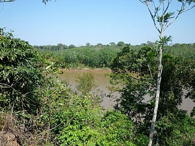
At the end of the green trail, which follows the river, we cut a new trail over a ridge that descends to the quebrada. We figured we could swim across the stream then bushwhack our way along the shoreline to the lodge. We were desperate to get there.
Unfortunately, at the bottom of the ridge, Elissa hacked into a wasps’ nest. She and I both got stung a couple times, so we scurried back up the ridge and gave up that exploit.
We then went to the swimming hole, thinking we could swim to the Tambopata swimming hole and use their trail from there; however, we didn’t know whether to swim upstream or downstream and with our hiking/rubber boots and machetes, this posed a problem. When we only had to swim across the mouth of the stream, it hadn’t seemed like such a big deal, but navigating a creek with lots of rocks was slightly more treacherous.
So we went back home, our first attempt at bushwhacking at Picaflor unsuccessful.
Speculation on Bushwhacking at Picaflor
Later on, we were in Pico’s boat, headed towards the Lodge for daily soccer games that attract Pico a few times a week. Elissa speculated that if the river was low enough, it would be possible to walk along the muddy/sandy banks and just swim across the quebrada.
Now, the river level fluctuates hourly, never mind daily. I learned from A Neotropical Companion: An Introduction to the Animals, Plants, and Ecosystems of the New World Tropics by John Kricher that even in dry season, the water can rise drastically if snow is melting in the Andes and flooding the rivers that eventually spill into the Amazon Basin.
Well, it’s only the start of rainy season now and with climate alternating between two or three killer hot days, two or three cloudy days, and two or three rainy days, I figure evaporation plays a role as well.
When I first got here, the water was unbelievably low (though I didn’t know it at the time). I’ve seen it rise by 30 to 40 feet since then, fluctuating every day, but it’s never been as low as when I got here.
Second Attempt Bushwhacking at Picaflor
Yesterday afternoon, Johanna went down to the river and came back to tell me to check out how low the water was. She hadn’t seen it at that level yet, but when I saw it, I knew this might be our chance to get over to the Lodge. The time had come for another attempt at bushwhacking at Picaflor.
With Pico gone once again, this time for three days, we had the misfortune of the fridge breaking again. Plus, it was one of those killer hot days and I’d been dying for something cold to drink all afternoon.
Off we went, barefoot because the banks are so muddy. We had put the stuff we wanted to bring in a plastic bag and put the bag in another plastic bag for added security following a waterproofing test.
Along the way, we saw tracks leading from the shore to the water. What could they have been? The tracks didn’t seem to have feet, just nails, but the structure was not that of a bird’s tracks. They were like scratch marks, like four nails, not too widely spaced, all pointing in the same direction. The tracks clearly went from the trees to the river and back. Had they belonged to a cayman, the tracks would have included the marks of a body being dragged between the paw prints, so I really don’t know…
We occasionally crawled along when the banks were too muddy to allow us to stand. We sank knee deep a few times; weight distribution was necessary.
Sometimes the terrain was rocky, other times sandy. One spot could have been an awesome river beach if it wasn’t submerged most of the time.
We arrived at a point where the land jutted into the river, a sheer wall. We didn’t want to go into the water here (it’s really muddy and gross, people throw all kinds of garbage into the river), and we didn’t think the shoreline, submerged by who knows how many feet of water, would support our weight if it was indeed shallow enough to walk around. The banks were at their muddiest here.
The only other option was to go up and over the hill, but neither one of us fancied walking in the woods barefoot (army ants).
Part of the cliff was muddy, free of leafy or woody debris, so I went up to scout the situation, hoping it went right back down to the bank on the other side.
No such luck: an earthy path led into the selva and tangled vines and branches — we would need machetes, not to mention shoes. In the earth, I saw large cat prints that couldn’t be more than three days old, since the last rain. I’m not even venturing a guess at what kind of cat it could be.
Defeated, we made our way home, bushwhacking at Picaflor forgotten for now.


Search Niackery
×